Thornhill (Grant Hill) Aquifer Hydrology
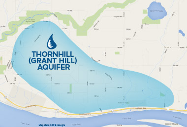
The Thornhill Aquifer is a bedrock aquifer that covers an area of approximately 19 square kilometres. It is located in the eastern rural area of Maple Ridge encompassing the communities of Thornhill, Whonnock and Ruskin. It is primarily made up of sandstone and shale with some areas covered with an overburden of gravel layers.
What is an aquifer?
An aquifer consists of underground layer(s) of saturated sand, gravel and/ or fractured rock that provides groundwater in significant quantities for wells. The shallow wells in our testing group are generally under 20 feet. The well recovery often depends on seasonal weather patterns and the water table. The deep or drilled wells in our testing group range from 260 feet to 560 feet. The recovery levels are generally slower, but the static levels have been very consistent throughout our ten year study.
Measuring a drilled test well
A shallow test well with TAPS founders,
Klaus & Betty von Hardenberg
IIA Aquifer
The Grant Hill Aquifer is the principal source of natural well water for both domestic and agricultural use. The Ministry of Environment classifies this aquifer as IIA, meaning that it is situated in a moderately developed area and is Highly Vulnerable to contamination because the thin soil layer over fractured bedrock does not provide an effective barrier.
Highly
vulnerable
to contamination
raising awareness
TAPS had received a grant from the Ministry of Environment to design and install aquifer protection signs in our community. This was an initiative of TAPS to raise awareness of our special groundwater protection area.

- CONSERVE WATER
- AVOID
contaminants infiltrating to the ground such as chemicals, pesticides, oil, gas, antifreeze, manure etc. - PROPERLY DISPOSE
of toxic and hazardous household products including prescription medications. - KEEP
garbage, cigarette butts and beverage cans off roadways, ditches and public places. - MAINTAIN
your septic system with regular
cleaning and inspection. - MAJOR disturbances
to the ground such as blasting or earthquakes will affect the fissures or pathways that carry the water to the deep wells. - REMEMBER, trees provide the catchment of precipitation that improves the slow saturation, filtration and recharge of groundwater for this aquifer.
Here are the ways to protect the Grant Hill Aquifer:
For further information
and detailed
diagrams refer to:
Guide to Using The B.C. Aquifer
Classification Map for the Protection
and Management of Groundwater
Groundwater Environment Canada
TAPS would like to thank the City of Maple Ridge, Ministry of Environment, Ministry of Agriculture, Agricultural Land Commission, Ministry of Health, TD Bank & CEED Centre for their support.
This website is made possible by the RBC Blue Water Project™. Website Photography by Emi Uchida
2016 © TAPS (Thornhill Aquifer Protection Study)
Maple Ridge, British Columbia
Email: tapsmapleridge(at)gmail(dot)com
Website by Pascal Bouchard Design